Metro Manila, over 20 provinces still face heavy rain from southwest monsoon
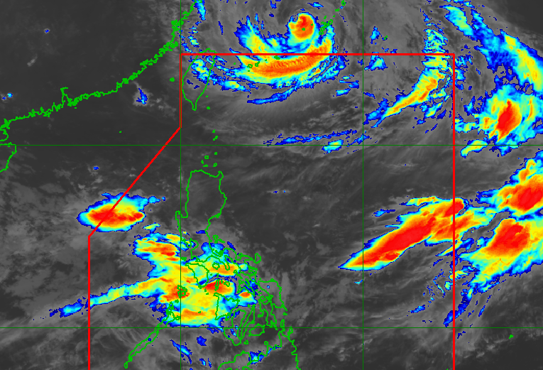
MANILA, Philippines – Metro Manila and 23 provinces are still seeing significant rainfall from the southwest monsoon or habagat, which is being enhanced by Typhoon Dolphin, on Saturday, August 8.
Dolphin remains outside the Philippine Area of Responsibility, and is still unlikely to enter PAR, according to the Philippine Atmospheric, Geophysical, and Astronomical Services Administration (PAGASA).
The typhoon was located 810 kilometers northeast of extreme Northern Luzon as of 3 am on Saturday, moving southwest at 15 kilometers per hour (km/h).
It has maximum sustained winds of 155 km/h and gustiness of up to 190 km/h.
While Dolphin will stay outside PAR, its enhancement of the southwest monsoon persists. Here is PAGASA’s latest three-day rainfall outlook for the southwest monsoon, issued at 5 am on Saturday:
Saturday, August 8
- Heavy to intense rain (100-200 millimeters): Ilocos Sur, La Union, Abra, Benguet, Zambales, Bataan, Occidental Mindoro
- Moderate to heavy rain (50-100 mm): Ilocos Norte, Pangasinan, Apayao, Kalinga, Mountain Province, Ifugao, Nueva Vizcaya, Tarlac, Nueva Ecija, Pampanga, Bulacan, Metro Manila, Rizal, Cavite, Batangas, Oriental Mindoro, Antique
Sunday, August 9
- Heavy to intense rain (100-200 mm): Ilocos Sur, La Union, Benguet, Zambales, Bataan, Occidental Mindoro
- Moderate to heavy rain (50-100 mm): Ilocos Norte, Pangasinan, Abra, Kalinga, Mountain Province, Ifugao, Nueva Vizcaya, Tarlac, Nueva Ecija, Pampanga, Bulacan, Metro Manila, Rizal, Cavite, Batangas, Oriental Mindoro, Antique
Monday, August 10
- Heavy to intense rain (100-200 mm): La Union, Benguet, Zambales, Bataan
- Moderate to heavy rain (50-100 mm): Ilocos Norte, Ilocos Sur, Abra, Pangasinan, Tarlac, Nueva Ecija, Pampanga, Cavite, Batangas, Occidental Mindoro, Antique
Affected areas must continue to watch out for floods and landslides.
Aside from the southwest monsoon and Dolphin, PAGASA is monitoring a new low pressure area (LPA) outside PAR, located 2,610 kilometers east of Northern Luzon at 3 am on Saturday.
The LPA has a high chance of developing into a tropical depression within 24 hours.
PAGASA Weather Specialist Veronica Torres said the LPA appears less likely to enter PAR, but she advised the public to monitor updates.
The weather bureau earlier predicted that two to four tropical cyclones could develop within or enter PAR in August. So far, there have been two: Tropical Depression Luis and Tropical Storm Maymay (Kujira). – Rappler.com